 Back Back  Index Index  Forward Forward  Other useful information Other useful information
*Christchurch North and Coast
Christchurch,
the garden city, and home of the largest windsurfing club in the
South Island. This is probably because of the wide range of
places to sail; lakes harbour, ocean, and there are several
windsurfing shops to choose gear from. In winter, the Mt Hutt ski
fields are just an hours drive away, and mountain biking
exploration is un- limited.Starting inland, the two main lake
locations are Coleridge and Clearwater. Closer to the coast is
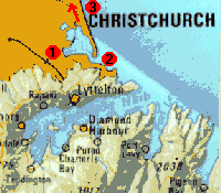
lake Ellesmere and the Christchurch estuary. Just around from the
estuary we have Sumner, and the other beaches along the coast
north of Christchurch. Over the hill from Christchurch is
Lyttelton Harbour, and slightly further away is Akaroa.
 Dial-a-forecast: 0900 999 33 / 0900
499 10 Dial-a-forecast: 0900 999 33 / 0900
499 10
 Info
Centre: Cnr Worcester & Oxford Tce. Ph 03 379 9629 Info
Centre: Cnr Worcester & Oxford Tce. Ph 03 379 9629
 Local
Shops: Local
Shops:
- Eastcoast Windsurf and Ski. 1091 Ferry Rd. Ph 03 384 3788
- Canterbury Windsurf. 3/ 1091 Ferry Rd. Ph 03 384 1741
    
Access: Such a popular place to
sail, that the Canterbury Windsurfing Association has
developed a windsurfing park there: showers, wash down area,
ramp, parking & grass rigging & BBQ areas etc.
Suits: Slalom, longboarding. Beginners......
Wind: NE = predominant and reliable 12 - 18
knots, can reach 25 knots. NW occasionally in summer and S in
winter.
Water: Flat and shallow. Sailable 3 hours
either side of high tide.
Watch: Other sailors when it's busy - take
note of the 'right-of-way rules' sign at the park.
Hire Schools: From either of the above
shops.
In Detail: The place where every
Christchurch wind-surfer learned. Making one of the eastern
borders of the city, it's close no matter where you
live/stay. Being an estuary it's tidal, good for sailing
about 1.5hrs before high, 2.5 after. At high tide only the
channels are over most people's head. This is the safest
location to sail at, you can't come to any serious harm (as
long as you keep out of other people's way). The biggest
problem is congestion. On a good day in summer, numbers
easily get to 500+, and you have to share the place with
three other yacht clubs. The estuary can be sailed in all
winds, but the easterly sea breeze is by far the best. It
comes up about lunchtime, depending on the amount of cloud
cover, and how long it takes the plains to warm up. It often
gets to 15-20kts, and is usually very steady. Good chop
jumping can be enjoyed, and the estuary is serviced by three
wind-surfing shops, so if anything breaks, you can be back on
the water within minutes.
I was probably wrong when I said congestion was the biggest
problem, getting the tide and the wind synchronised is
probably worse. However if the tide is out, and you can water
start, then there is always Lyttelton Harbour.
   
Access: 10 minutes from the city. Sumner beach is
patrolled and there's plenty of parking and grass rigging
areas.
Suits: Slalom, wavesailing. Intermediate...
Wind: NW = cross shore. NE = cross onshore.
.
Water: Small to medium waves, better for
jumping than riding. Waist deep between waves - good for
learning to wavesail.
Watch: Swimmers. Undertow which carries
sideways south.
In Detail: All these beaches are sailed in
northerlies and westerlies, cross-offshore conditions. The
more northern beaches are cross shore in notherlies.
Following the coast south, back to Christchurch, it curves
east, meaning these beaches are cross shore in nor-westers,
and westerlies. Most of these beaches are popular summer
swimming locations and are patrolled over the weekends and
school holidays. Most of them are notorious for their
pot-holes and rips, so sailing alone is not a good idea.
Sumner is the most popular wave location in Christchurch, and
is usually quite busy in a nor-west. It's five minutes drive
from the estuary, so is also close to the shops if repairs
are needed. I'm no expert when it comes to these locations as
I've only sailed here once or twice, but on a good day I
would guess at 2m breaks. It's certainly possible to pull off
loops here (I've got the photos to prove it).
  
Access: 1.30 hour drive north of the estuary at the
farthest end of Pegasus Bay. Picnic, rigging and parking
areas. Sail out north to the point and reef.
Suits: Wavesailing. Intermediate...
Wind: NE = cross shore.
Water: Easy waves.
Watch: The reef. Choppy seas. Banks of kelp
out the back which mark pillars of rock.
 ...more information ...more information
 Top Top Back Back  Index Index  Forward Forward  Other useful information Other useful information
|